
Saturday 30 April 2016


Friday 29 April 2016


Thursday 28 April 2016


Kind heart of people
In the modern world, every people are busy. No one have any time to spend with others. All are trying to live with wealth and happiness. But one are not want live with out soul satisfaction. Some are cheating others for the need of money or there personal need.
Just think about the earth. What is the earth. What is he job or work of earth. If earth is the mother of all living thinks, there we can read many points about the life. Our mother not want our love when the age of below 4. That time she give love to only us.
The topic is waiting for complete. Soon .
Wednesday 27 April 2016

Tuesday 26 April 2016

Monday 25 April 2016

Sunday 24 April 2016


Which day is World Tuberculosis Day ?
World Tuberculosis Day, falling on March 24 each year, is designed to build public awareness about the global epidemic of tuberculosis (TB) and efforts to eliminate the disease. In 2012, 8.6 million people fell ill with TB, and 1.3 million died from the disease, mostly in the Third World.
World TB Day is one of eight official global public health campaigns marked by the World Health Organization (WHO), along with World Health Day, World Blood Donor Day, World Immunization Week, World Malaria Day, World No Tobacco Day, World Hepatitis Day and World AIDS Day.
March 24 commemorates the day in 1882 when Dr Robert Koch astounded the scientific community by announcing to a small group of scientists at the University of Berlin's Institute of Hygiene that he had discovered the cause of tuberculosis, the TB bacillus. According to Koch’s colleague, Paul Ehrlich, “At this memorable session, Koch appeared before the public with an announcement which marked a turning-point in the story of a virulent human infectious disease. In clear, simple words Koch explained the aetiology of tuberculosis with convincing force, presenting many of his microscope slides and other pieces of evidence.”At the time of Koch's announcement in Berlin, TB was raging through Europe and the Americas, causing the death of one out of every seven people. Koch's discovery opened the way toward diagnosing and curing tuberculosis.
In 1982, on the one-hundredth anniversary of Robert Koch's presentation, the International Union Against Tuberculosis and Lung Disease (IUATLD) proposed that March 24 be proclaimed an official World TB Day. This was part of a year-long centennial effort by the IUATLD and the World Health Organization under the theme “Defeat TB: Now and Forever.” World TB Day was not officially recognized as an annual occurrence by WHO's World Health Assembly and the United Nations until over a decade later.
In the fall of 1995, WHO and the Royal Netherlands Tuberculosis Foundation (KNCV) hosted the first World TB Day advocacy planning meeting in Den Haag, Netherlands; an event they would continue co-sponsor over the next few years. In 1996, WHO, KNCV, the IUATLD and other concerned organizations joined to conduct a wide range of World TB Day activities.
For World TB Day 1997, WHO held a news conference in Berlin during which WHO Director-General Hiroshi Nakajima declared that “DOTS is the biggest health breakthrough of this decade, according to lives we will be able to save.” WHO's Global TB Programme Director, Dr. Arata Kochi, promised that, "Today the situation of the global TB epidemic is about to change, because we have made a breakthrough. It is the breakthrough of health management systems that makes it possible to control TB not only in wealthy countries, but in all parts of the developing world, where 95 percent of all TB cases now exist."
By 1998, nearly 200 organizations conducted public outreach activities on World TB Day. During its World TB Day 1998 news conference in London, WHO for the first time identified the top twenty-two countries with the world’s highest TB burden. The next year, over 60 key TB advocates from 18 countries attended the three-day WHO/KNCV planning meeting for World TB Day 1999.
U.S. President Bill Clinton marked World TB Day 2000 by administering the WHO-recommended DOTS treatment to patients at the Mahavir Hospital in Hyderabad, India. According to Clinton, “These are human tragedies, economic calamities, and far more than crises for you, they are crises for the world. The spread of disease is the one global problem for which . . . no nation is immune.”
In Canada, the National Collaborating Centre for Determinants of Health noted on World TB Day 2014 that 64% of TB cases reported nationally were among foreign-born individuals and 23% among Aboriginal people, highlighting TB as a key area of concern about health equity.
Today the Stop TB Partnership, a network of organizations and countries fighting TB (the IUATLD is a member and WHO houses the Stop TB Partnership secretariat in Geneva), organizes the Day to highlight the scope of the disease and how to prevent and cure it.
Saturday 23 April 2016

Friday 22 April 2016


Thursday 21 April 2016


Wednesday 20 April 2016

Sunday 17 April 2016
Look carefully; what you feel ?
Comments here....
About this picture.
May be you became a poet.
I have many words ....
In my heart....
But the feeling ...in deep..

Saturday 16 April 2016


Friday 15 April 2016

WHICH IS THE LARGEST PENINSULA IN THE WORLD ?
ARABIA.
A peninsula is a piece of land that is bordered by water on three sides but connected to mainland.The surrounding water is usually understood to belong to a single contiguous body, but is not always explicitly defined as such. A peninsula can also be a headland, cape, island promontory, bill, point, or spit. A point is generally considered a tapering piece of land projecting into a body of water that is less prominent than a cape. In English, the plural of peninsula is peninsulas or, less commonly, peninsulae. A river which courses through a very tight meander is also sometimes said to form a "peninsula" within the (almost closed) loop of water.
Who is the first Prime Minister of Great Britain ?
Robert Walpole, 1st Earl of Orford, KG KB PC (26 August 1676 – 18 March 1745), known before 1742 as Sir Robert Walpole, was a British statesman who is generally regarded as the first Prime Minister of Great Britain. Although the exact dates of his dominance are a matter of scholarly debate, 1721–1742 are often used. He dominated the Walpole–Townshend Ministry and the Ministry and holds the record as the longest serving Prime Minister in British history. Critics called his system the "Robinocracy." Speck says that Walpole's uninterrupted run of 20 years as Prime Minister "is rightly regarded as one of the major feats of British political history.... Explanations are usually offered in terms of his expert handling of the political system after 1720, his unique blending of the surviving powers of the crown with the increasing influence of the Commons."
He was a Whig from the gentry class, who was first elected to parliament in 1701, and held many senior positions. He was a country squire and looked to country gentlemen for his political base. Historian Frank O'Gorman says his leadership in Parliament reflected his "reasonable and persuasive oratory, his ability to move both the emotions as well as the minds of men, and, above all, his extraordinary self-confidence." Hoppit says Walpole's policies sought moderation: he worked for peace, lower taxes, growing exports, and allowed a little more tolerance for Protestant Dissenters. He avoided controversy and high-intensity disputes, as his middle way attracted moderates from both the Whig and Tory camps.
Walpole was one of the greatest politicians in British history. He played a significant role in sustaining the Whig party, safeguarding the Hanoverian succession, and defending the principles of the Glorious Revolution (1688)....He established a stable political supremacy for the Whig party and taught succeeding ministers how best to establish an effective working relationship between Crown and Parliament
WHO IS THE FIRST PERSON TO REACH SOUTH POLE IN THE WORLD ?
Roald Amundsen.
The first expedition to reach the geographic South Pole was led by the Norwegian explorer Roald Amundsen. He and four others arrived at the pole on 14 December 1911, five weeks ahead of a British party led by Robert Falcon Scott as part of the Terra Nova Expedition. Amundsen and his team returned safely to their base, and later learned that Scott and his four companions had died on their return journey.
Amundsen's plans had focused on the Arctic and the conquest of the North Pole by means of an extended drift in an icebound ship. He obtained the use of Fridtjof Nansen's polar exploration ship Fram, and undertook extensive fundraising. Preparations for this expedition were disrupted when, in 1909, the rival American explorers Frederick Cook and Robert E. Peary each claimed to have reached the North Pole. Amundsen then changed his plan and began to prepare for a conquest of the South Pole; uncertain of the extent to which the public and his backers would support him, he kept this revised objective secret. When he set out in June 1910, he led even his crew to believe they were embarking on an Arctic drift, and revealed their true Antarctic destination only when Fram was leaving their last port of call, Madeira.
Amundsen made his Antarctic base, "Framheim", in the Bay of Whales on the Great Ice Barrier. After months of preparation, depot-laying and a false start that ended in near-disaster, he and his party set out for the pole in October 1911. In the course of their journey they discovered the Axel Heiberg Glacier, which provided their route to the polar plateau and ultimately to the South Pole. The party's mastery of the use of skis and their expertise with sledge dogs ensured rapid and relatively trouble-free travel. Other achievements of the expedition included the first exploration of King Edward VII Land and an extensive oceanographic cruise.
The expedition's success was widely applauded. The story of Scott's heroic failure overshadowed its achievement in the United Kingdom, unable to accept that a Norwegian had been the first person to set foot in the South Pole, but not in the rest of the world. Amundsen's decision to keep his true plans secret until the last moment was criticised by some. Recent polar historians have more fully recognised the skill and courage of Amundsen's party; the permanent scientific base at the pole bears his name, together with that of Scott.
Thursday 14 April 2016

Wednesday 13 April 2016


Tuesday 12 April 2016
The Bay of Bengal, the largest bay in the world,

The Bay of Bengal, the largest bay in the world, forms the northeastern part of the Indian Ocean. Roughly triangular, it is bordered mostly by India and Sri Lanka to the west, Bangladesh to the north, and Myanmar (Burma) and the Andaman and Nicobar Islands to the east.
The Bay of Bengal occupies an area of 2,172,000 square kilometres (839,000 sq mi). A number of large rivers – the Ganges and its tributaries such as the Padma and Hooghly, the Brahmaputra and its tributaries such as the Jamuna and Meghna, other rivers such as the Irrawaddy River, Godavari, Mahanadi, Krishna and Kaveri flow into the Bay of Bengal. Among the important ports are Chennai, Chittagong, Kolkata, Mongla, Paradip, Tuticorin, Visakhapatnam and Yangon.
Many major rivers of the Indian subcontinent flow west to east before draining into the Bay of Bengal. The Ganges is the northernmost of theses. Its main channel enters and flows through Bangladesh, where it is known as the Padma River, before joining the Meghna River. However, the Brahmaputra River flows from east to west in Assam before turning south and entering Bangladesh where it is called the Jamuna River. This joins the Padma whereupon the Padma joins the Meghna River that finally drains into Bay of Bengal. The Sundarbans mangrove forest at the delta of the Ganges, Brahmaputra and Meghna rivers lies partly in West Bengal and partly in Bangladesh. The Brahmaputra at 2,948 km (1,832 mi) is the 28th longest River in the world. It originates in Tibet. The Hooghly River, another channel of the Ganga that flows through Calcutta drains into Bay of Bengal in India itself.
The Ganga–Brahmaputra rivers deposits nearly 1000 million tons of sediment per year. The sediment from these two rivers forms the Bengal Delta and the submarine fan, a vast structure that extends from Bangladesh to south of the Equator, is up to 16.5 kilometres (10.3 mi) thick, and contains at least 1,130 trillion tonnes of sediment, which has accumulated over the last 17 million years at an average rate of 665 million tons per annum. The Bay of Bengal used to be deeper than the Mariana Trench, the present deepest ocean point. The fan has buried organic carbon at a rate of nearly 1.1 trillion mol/yr since the early Miocene period. The two rivers currently contribute nearly 8% of the total organic carbon (TOC) deposited in the world's oceans. Due to high TOC accumulation in the deep sea bed of the Bay of Bengal, the area is rich in oil and natural gas and gas hydrate reserves. Bangladesh can reclaim land substantially and economically from the sea area by constructing sea dikes, bunds, causeways and by trapping the sediment from its rivers.
Further south of Bengal, the Mahanadi, Godavari, Krishna and Kaveri Rivers are the major rivers that flow from west to east in the Indian subcontinent and drain into the Bay of Bengal. Many small rivers also drain directly into the Bay of Bengal; the shortest of them is the Cooum River at 64 km (40 mi).
The Irrawaddy (or Ayeyarwady) River in Myanmar flows into the Andaman Sea of the Bay of Bengal and once had thick mangrove forest of its own.
The Bay of Bengal is strategically crucial for India since it is a natural extension of its sphere of influence. Secondly because of the presence of outlying islands, namely Andaman islands and Nicobar islands and most importantly several major ports such as Kolkata, Chennai, Visakhapatnam, and Tuticorin along its coast with the Bay of Bengal.
China has recently made some efforts to project influence into the region through tie-ups with Myanmar and Bangladesh.The United States has held several major exercises with Bangladesh, India, Malaysia, Singapore and Thailand. The largest ever wargame in Bay of Bengal, known as Malabar 2007, was held in 2007 and naval warships from US, Singapore, Japan and Australia took part in it. India, was also a participant. Large deposits of natural gas also incited a serious up for grabs urgency by India. Disputes over rights of some oil and gas blocks have caused brief diplomatic spats between Myanmar and India with Bangladesh.
The disputed maritime boundary between Bangladesh and Myanmar has twice resulted in military tensions, in 2008 and 2009. Bangladesh is currently pursuing a settlement with Myanmar and India to the boundary dispute through the International Tribunal on the Law of the Sea.
It has been argued that the conceptual division of the Bay of Bengal region between South Asia and Southeast Asia may no longer be appropriate and that the rise of India as a major power may lead to a new mental mapping of the Bay of Bengal as a coherent strategic region.
The Millau Viaduct - highest bridge in the world
The Millau Viaduct is a cable-stayed bridge that spans the valley of the River Tarn near Millau in southern France.

Designed by the French structural engineer Michel Virlogeux and British architect Norman Foster, it is the tallest bridge in the world with one mast's summit at 343.0 metres (1,125 ft) above the base of the structure.It is the 15th highest bridge deck in the world, being 270 metres (890 ft)between the road deck and the ground below. The Millau Viaduct is part of the A75-A71 autoroute axis from Paris to Béziers and Montpellier. The cost of construction was approximately €400 million. It was formally inaugurated on 14 December 2004, and opened to traffic on 16 December. The bridge has been consistently ranked as one of the great engineering achievements of all time.The bridge received the 2006 International Association for Bridge and Structural Engineering Outstanding Structure Award.
 Because of problems with traffic on the route from Paris to Spain along the stretch passing through the Tarn valley near the town of Millau, leading to congestion in the summer from holiday traffic, construction of a bridge to span the valley was required. The first plans were discussed in 1987 by CETE, and by October 1991, the decision was made to build a high crossing of the Tarn River by a structure of around 2,500 m (8,200 ft) in length. During 1993–1994 the government consulted with seven architects and eight structural engineers. During 1995–1996, a second definition study was made by five associated architect groups and structural engineers. In January 1995, the government issued a declaration of public interest to solicit design approaches for a competition.
In July 1996, the jury decided in favour of a cable-stayed design with multiple spans, as proposed by the Sogelerg consortium (Michel Virlogeux and Norman Foster). The decision to proceed by grant of contract was made in May 1998; then in June 2000 the contest for the construction contract was launched, open to four consortia. In March 2001 Eiffage established the subsidiary Compagnie Eiffage du Viaduc de Millau (CEVM) and was declared winner of the contest and awarded the prime contract in Augus.
 The Millau Viaduct is located on the territory of the communes of Millau and Creissels, France, in the département of Aveyron. Before the bridge was constructed, traffic had to descend into the Tarn River valley and pass along the route nationale N9 near the town of Millau, causing heavy congestion at the beginning and end of the July and August holiday season. The bridge now traverses the Tarn valley above its lowest point, linking two limestone plateaus, the Causse du Larzac and the Causse Rouge, and is inside the perimeter of the Grands Causses regional natural park.
The bridge forms the last link of the A75 autoroute (la Méridienne), from Clermont-Ferrand to Pézenas (to be extended to Béziers by 2010). The A75, with the A10 and A71, provides a continuous high-speed route south from Paris through Clermont-Ferrand to the Languedoc region and through to Spain, considerably reducing the cost of vehicle traffic travelling along this route. Many tourists heading to southern France and Spain follow this route because it is direct and without tolls for the 340 kilometres (210 mi) between Clermont-Ferrand and Pézenas, except for the bridge itself.
The Eiffage group, which constructed the viaduct, also operates it, under a government contract which allows the company to collect tolls for up to 75 years. The toll bridge costs €7.50 for light automobiles (€9.40 during the peak months of July and August)
Mount Isa (/ˈaɪzə/ eye-zə)- city in the Gulf Country - Largest town in the world

Mount Isa (/ˈaɪzə/ eye-zə) is a city in the Gulf Country region of Queensland, Australia. It came into existence because of the vast mineral deposits found in the area. Mount Isa Mines (MIM) is one of the most productive single mines in world history, based on combined production of lead, silver, copper and zinc.
With an estimated population of 22,517 as at June 2015, Mount Isa is the administrative, commercial and industrial centre for the state's vast north-western region. Although situated in an arid area, the artificial Lake Moondarra19 kilometres (12 mi) north of the city on the Leichhardt River provides both drinking water and an area for watersports, birdwatching and recreation. Locals often refer to Mount Isa as "The Isa".
Due to the lead production in the city, Mount Isa has one of the most intensive air quality monitoring systems in Australia. Concerns have been raised over childhood lead contamination and air pollution within the city.
The land around the present day city of Mount Isa was home to the Kalkadoon aboriginal tribe. The Kalkadoon tribe led a subsistence lifestyle on this land that the white settlers looked at as nothing but poor grazing land, with the odd mineral deposit. As settlers and prospectors pressed further into their lands the Kalkadoon tribe members set out on one of Australia's most successful guerrilla wars in a fight for their lands. Their success continued until at Battle Mountain in 1884, with what some historians have called a rush of blood, the tribe attacked a fortified position in large numbers and suffered terrible losses. The weakened state of the tribe made their land more vulnerable to the settlers and soon much of the land was lost. Armed patrols chasing the surviving tribe members and poor grazing lands for the settlers made times hard in the area over the following decades.
It is said that a lone prospector, John Campbell Miles, stumbled upon one of the world's richest deposits of copper, silver and zinc during his 1923 expedition into the Northern Territory, but many people do not know that he was taken to the deposits by a young aboriginal man by the name of Kabalulumana (for whom an Indigenous person's hostel in Mount Isa is named). When Miles inspected the yellow-black rocks in a nearby outcrop, they reminded him of the ore found in the Broken Hill mine that he had once worked at. Upon inspection these rocks were weighty and heavily mineralised. A sample sent away to the assayer in Cloncurry confirmed their value. Miles and four farmers staked out the first claims in the area. Taken with friend's stories of the Mount Ida gold mines in Western Australia, Miles decided upon Mount Isa as the name for his new claim.
Mount Isa Post Office opened on 1 August 1924.
A location for the town's hospital was chosen in 1929, with a small building completed the following year.[9] In 1931, a larger structure was moved to the site from the closed mining town of Kuridala.[9]
Attractions include the Hard Times Mine at "Outback at Isa" and The Mount Isa Rodeo and Mardi Gras (held on the same weekend) has given Mount Isa the title of "Rodeo Capital of Australia". The occasion may well triple the city's population in these few days.[citation needed] A memorial has been made especially for the Rodeo, down Rodeo Drive; the sidewalks have special memorials embedded in the cement.
The burial place of John Campbell Miles, the founder of Mount Isa, is on the corner of Rodeo Drive and Miles Street. His ashes are buried underneath a large statue where each panel represents a significant part of Mount Isa. Miles' ashes used to be watched over by a large clock where the statue now stands.
The World War II-era Mount Isa Underground Hospital is an historical building that has been registered on the Register of the National Estate and the Queensland Heritage Register. It is an air-raid shelter which could function as a hospital was a precautionary measure taken after Darwin was bombed in 1942.[9] Local miners excavated the site which remains today as the only underground health facility in Queensland which was built during World War II.
The Xstrata Mount Isa Lake Moondarra Fishing Classic is held annually, and after 2011 will also be followed by a Fishing, Camping and 4x4 Expo. The Fishing classic is the richest fresh water fishing event in Queensland. Catching the tagged Barramundi fetches the greatest prize money
The Istana Nurul Iman palace(Jawi: ايستان نورول ايمان) -world's largest palace
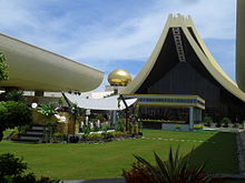 The Istana Nurul Iman palace (Jawi: ايستان نورول ايمان) is the official residence of the Sultan of Brunei, Hassanal Bolkiah, and the seat of the Brunei government. The palace is located on a leafy, riverside sprawl of hills on the banks of the Brunei River, a few kilometers south of Bandar Seri Begawan, Brunei's capital.The name "Istana Nurul Iman" is taken from Malay Istana and Arabic Nur-ol Imaan and means Palace of the Light of Faith. It was designed by Filipino architect Leandro V. Locsin, who utilized the architectural motif of golden domes and vaulted roofs to echo Brunei's Islamic and Malay influences. The interior of the palace was designed by Khuan Chew, Design Principal of KCA International, whose other works include the Burj Al Arab in Dubai. Construction was handled by Ayala International, a Filipino construction firm, and completed in 1984 at a total cost of around $1.4 Billion USD.
Upon completion, Istana Nurul Iman, became the largest residential palace in the world and the largest single family residence ever built.
The palace contains 1,788 rooms, which includes 257 bathrooms, a banquet hall that can be expanded to accommodate up to 5,000 guests, a mosque accommodating 1,500 people. The palace also includes a 110-car garage, an air conditioned stable for the Sultan's 200 polo ponies, and 5 swimming pools. In total, Istana Nurul Iman contains 2,152,782 square feet (200,000 m²) of floorspace.
Because of its massive size, Istana Nurul Iman makes use of 564 chandeliers, 51,000 light bulbs, 44 stairwells, and 18 elevators.
The title of the "world's largest palace" is difficult to ascertain, and controversial, as different countries use their own unique standard to claim that their palace is the largest. Using various definitions, a number of palaces are claimed to be the world’s largest: Istana Nurul Iman, Buckingham Palace, Quirinal Palace, Royal Palace of Madrid, Stockholm Palace, The Forbidden City, The Palace of Versailles, The Royal Palace of Caserta, The Winter Palace, The Louvre Palace, Prague Castle, and Romania’s Palace of the Parliament.
To be considered for the Guinness World Record, the palace must have been intended for use as a royal residence, and only the combined area of the palace’s indoor floors (a measurement commonly known as floorspace) is considered. As measured by these standards, Guinness World Records currently considers Istana Nurul Iman to hold the title as the "world's largest residential palace.


Monday 11 April 2016

Sunday 10 April 2016
Know about The Dead Sea.
The Dead Sea (Hebrew: יָם הַמֶּלַח, Yām HaMélaḥ, "Sea of Salt", also Hebrew: יָם הַמָּוֶת, Yām HaMā́weṯ, "The Sea of Death", and Arabic: البحر الميت al-Baḥr al-Mayyit ), also called the Salt Sea, is a salt lake bordered by Jordan to the east and Israel and the West Bank to the west. Its surface and shores are 429 metres (1,407 ft) below sea level, Earth's lowest elevation on land. The Dead Sea is 304 m (997 ft) deep, the deepest hypersaline lake in the world. With 34.2% salinity (in 2011), it is also one of the world's saltiest bodies of water, though Lake Vanda in Antarctica (35%), Lake Assal in Djibouti (34.8%), Lagoon Garabogazköl in the Caspian Sea (up to 35%) and some hypersaline ponds and lakes of the McMurdo Dry Valleys in Antarctica (such as Don Juan Pond (44%)) have reported higher salinities. It is 9.6 times as salty as the ocean.This salinity makes for a harsh environment in which animals cannot flourish, hence its name. The Dead Sea is 50 kilometres (31 mi) long and 15 kilometres (9 mi) wide at its widest point. It lies in the Jordan Rift Valley and its main tributary is the Jordan River.
The Dead Sea has attracted visitors from around the Mediterranean basin for thousands of years. In the Bible, it is a place of refuge for King David. It was one of the world's first health resorts (for Herod the Great), and it has been the supplier of a wide variety of products, from asphalt for Egyptian mummification to potash for fertilizers. People also use the salt and the minerals from the Dead Sea to create cosmetics and herbal sachets.
The Dead Sea water has a density of 1.24 kg/litre, which makes swimming similar to floating.
In Hebrew, the Dead Sea is Yām ha-Melaḥ (ים המלח), meaning "sea of salt" (Genesis 14:3). In the Bible, the Dead Sea is called the Salt Sea, the Sea of the Arabah, and the Eastern Sea. The designation "Dead Sea" never appears in the Bible.
In prose sometimes the term Yām ha-Māvet (ים המוות, "sea of death") is used, due to the scarcity of aquatic life there.In Arabic the Dead Sea is called al-Bahr al-Mayyit ("the Dead Sea"), or less commonly baḥrᵘ lūṭᵃ (بحر لوط, "the Sea of Lot"). Another historic name in Arabic was the "Sea of Zoʼar", after a nearby town in biblical times. The Greeks called it Lake Asphaltites (Attic Greek ἡ Θάλαττα ἀσφαλτῖτης, hē Thálatta asphaltĩtēs, "the Asphaltite sea"). The Bible also refers to it as Yām ha-Mizraḥî (ים המזרחי, "the Eastern sea") and Yām ha-‘Ărāvâ (ים הערבה, "Sea of the Arabah").
The Dead Sea is an endorheic lake located in the Jordan Rift Valley, a geographic feature formed by the Dead Sea Transform (DST). This left lateral-moving transform fault lies along the tectonic plate boundary between the African Plate and the Arabian Plate. It runs between the East Anatolian Fault zone in Turkey and the northern end of the Red Sea Rift offshore of the southern tip of Sinai. It is here that the Upper Jordan River/Sea of Galilee/Lower Jordan River water system comes to an end.
The Jordan River is the only major water source flowing into the Dead Sea, although there are small perennial springs under and around the Dead Sea, forming pools and quicksand pits along the edges. There are no outlet streams.
Rainfall is scarcely 100 mm (4 in) per year in the northern part of the Dead Sea and barely 50 mm (2 in) in the southern part.The Dead Sea zone's aridity is due to the rainshadow effect of the Judaean Mountains. The highlands east of the Dead Sea receive more rainfall than the Dead Sea itself.
To the west of the Dead Sea, the Judaean mountains rise less steeply and are much lower than the mountains to the east. Along the southwestern side of the lake is a 210 m (700 ft) tall halite formation called "Mount Sodom".
Saturday 9 April 2016
Read about Victor Marie Hugo
Victor Marie Hugo was a French poet, novelist, and dramatist of the Romantic movement. He is considered one of the greatest and best-known French writers. In France, Hugo's literary fame comes first from his poetry and then from his novels and his dramatic achievements. Among many volumes of poetry, Les Contemplations and La Légende des siècles stand particularly high in critical esteem. Outside France, his best-known works are the novels Les Misérables, 1862, and Notre-Dame de Paris, 1831 (known in English as The Hunchback of Notre-Dame). He also produced more than 4,000 drawings, which have since been admired for their beauty, and earned widespread respect as a campaigner for social causes such as the abolition of capital punishment.
Though a committed royalist when he was young, Hugo's views changed as the decades passed, and he became a passionate supporter of republicanism;. his work touches upon most of the political and social issues and the artistic trends of his time. He is buried in the Panthéon. His legacy has been honoured in many ways, including his portrait being placed on French franc banknotes.
Hugo published his first novel the year following his marriage (Han d'Islande, 1823), and his second three years later (Bug-Jargal, 1826). Between 1829 and 1840, he published five more volumes of poetry (Les Orientales, 1829; Les Feuilles d'automne, 1831; Les Chants du crépuscule, 1835; Les Voix intérieures, 1837; and Les Rayons et les Ombres, 1840), cementing his reputation as one of the greatest elegiac and lyric poets of his time.
Like many young writers of his generation, Hugo was profoundly influenced by François-René de Chateaubriand, the famous figure in the literary movement of Romanticism and France's pre-eminent literary figure during the early 19th century. In his youth, Hugo resolved to be "Chateaubriand or nothing", and his life would come to parallel that of his predecessor in many ways. Like Chateaubriand, Hugo furthered the cause of Romanticism, became involved in politics (though mostly as a champion of Republicanism), and was forced into exile due to his political stances.
The precocious passion and eloquence of Hugo's early work brought success and fame at an early age. His first collection of poetry (Odes et poésies diverses) was published in 1822, when Hugo was only 20 years old, and earned him a royal pension from Louis XVIII. Though the poems were admired for their spontaneous fervour and fluency, the collection that followed four years later in 1826 (Odes et Ballades) revealed Hugo to be a great poet, a natural master of lyric and creative song.
Victor Hugo's first mature work of fiction appeared in 1829, and reflected the acute social conscience that would infuse his later work. Le Dernier jour d'un condamné (The Last Day of a Condemned Man) would have a profound influence on later writers such as Albert Camus, Charles Dickens, and Fyodor Dostoyevsky. Claude Gueux, a documentary short story about a real-life murderer who had been executed in France, appeared in 1834, and was later considered by Hugo himself to be a precursor to his great work on social injustice, Les Misérables.
Hugo became the figurehead of the romantic literary movement with the plays Cromwell (1827) and Hernani (1830).
Hugo's novel Notre-Dame de Paris (The Hunchback of Notre-Dame) was published in 1831 and quickly translated into other languages across Europe. One of the effects of the novel was to shame the City of Paris into restoring the much-neglected Cathedral of Notre Dame, which was attracting thousands of tourists who had read the popular novel. The book also inspired a renewed appreciation for pre-Renaissance buildings, which thereafter began to be actively preserved.
Hugo began planning a major novel about social misery and injustice as early as the 1830s, but a full 17 years were needed for Les Misérables to be realised and finally published in 1862. Hugo was acutely aware of the quality of the novel[clarification needed] and publication of the work went to the highest bidder. The Belgian publishing house Lacroix and Verboeckhoven undertook a marketing campaign unusual for the time, issuing press releases about the work a full six months before the launch. It also initially published only the first part of the novel ("Fantine"), which was launched simultaneously in major cities. Instalments of the book sold out within hours, and had enormous impact on French society.
The critical establishment was generally hostile to the novel; Taine found it insincere, Barbey d'Aurevilly complained of its vulgarity, Gustave Flaubert found within it "neither truth nor greatness", the Goncourt brothers lambasted its artificiality, and Baudelaire – despite giving favourable reviews in newspapers – castigated it in private as "tasteless and inept". Les Misérables proved popular enough with the masses that the issues it highlighted were soon on the agenda of the National Assembly of France. Today, the novel remains his most enduringly popular work. It is popular worldwide, and has been adapted for cinema, television, and stage shows.
An apocryphal tale about the shortest correspondence in history is said to have been between Hugo and his publisher Hurst and Blackett in 1862. Hugo was on vacation when Les Misérables was published. He queried the reaction to the work by sending a single-character telegram to his publisher, asking ?. The publisher replied with a single ! to indicate its success.
Hugo turned away from social/political issues in his next novel, Les Travailleurs de la Mer (Toilers of the Sea), published in 1866. The book was well received, perhaps due to the previous success of Les Misérables. Dedicated to the channel island of Guernsey, where he spent 15 years of exile, Hugo tells of a man who attempts to win the approval of his beloved's father by rescuing his ship, intentionally marooned by its captain who hopes to escape with a treasure of money it is transporting, through an exhausting battle of human engineering against the force of the sea and a battle against an almost mythical beast of the sea, a giant squid. Superficially an adventure, one of Hugo's biographers calls it a "metaphor for the 19th century–technical progress, creative genius and hard work overcoming the immanent evil of the material world."
The word used in Guernsey to refer to squid (pieuvre, also sometimes applied to octopus) was to enter the French language as a result of its use in the book. Hugo returned to political and social issues in his next novel, L'Homme Qui Rit (The Man Who Laughs), which was published in 1869 and painted a critical picture of the aristocracy. The novel was not as successful as his previous efforts, and Hugo himself began to comment on the growing distance between himself and literary contemporaries such as Flaubert and Émile Zola, whose realist and naturalist novels were now exceeding the popularity of his own work.
His last novel, Quatre-vingt-treize (Ninety-Three), published in 1874, dealt with a subject that Hugo had previously avoided: the Reign of Terror during the French Revolution. Though Hugo's popularity was on the decline at the time of its publication, many now consider Ninety-Three to be a work on par with Hugo's better-known novels


Wednesday 6 April 2016


Monday 4 April 2016
The lion-tailed macaque (Macaca silenus), or the wanderoo - Old World monkey endemic to the Western Ghats of South India
 The lion-tailed macaque (Macaca silenus), or the wanderoo, is an Old World monkey endemic to the Western Ghats of South India.The hair of the lion-tailed macaque is black. Its outstanding characteristic is the silver-white mane which surrounds the head from the cheeks down to its chin, which gives this monkey its German name Bartaffe - "beard ape". The hairless face is black in colour. With a head-body length of 42 to 61 cm and a weight of 2 to 10 kg, it ranks among the smaller macaques. The tail is medium in length, about 25 cm, and has a black tuft at the end, similar to a lion's tail. The male's tail-tuft is more developed than that of the female.
Gestation is approximately six months. The young are nursed for one year. Sexual maturity is reached at four years for females, and six years for males. The life expectancy in the wild is approximately 20 years, while in captivity is up to 30 years.
 The lion-tailed macaque is a diurnal rainforest dweller. It is a good climber and spends a majority of its life in the upper canopy of tropical moist evergreen forests. Unlike other macaques, it avoids humans. In group behavior, it is much like other macaques; it lives in hierarchical groups of usually 10 to 20 animals, which consist of few males and many females. It is a territorial animal, defending its area first with loud cries towards the invading troops. If this proves to be fruitless, it brawls aggressively.
Lion-tailed macaque behaviour is characterized by typical patterns such as arboreal living, selectively feeding on a large variety of fruit trees, large interindividual spaces while foraging, and time budgets with high proportion of time devoted to exploration and feeding. It primarily eats indigenous fruits, leaves, buds, insects and small vertebrates in virgin forest, but can adapt to rapid environmental change in areas of massive selective logging through behavioural modifications and broadening of food choices to include fruits, seeds, shoots, pith, flowers, cones, mesocarp, and other parts of many nonindigenous and pioneer plants.In the forests of Kerala they were observed preying on nestling and eggs of pigeons.
A recent assessment for IUCN reports 3000-3500 of these animals live scattered over several areas in Kerala.The lion-tailed macaque ranks among the rarest and most threatened primates. Their range has become increasingly isolated and fragmented by the spread of agriculture and tea, coffee, teak and cinchona, construction of water reservoirs for irrigation and power generation, and human settlements to support such activities. They do not live, feed or travel through plantations. Destruction of their habitat and their avoidance of human proximity have led to the drastic decrease of their population.
From 1977 to 1980, public concern about the endanged status of lion-tailed macaque became the focal point of Save Silent Valley, India's fiercest environmental debate of the decade. From 1993 to 1996, 14 troops were observed in Silent Valley National Park, Kerala, one of the most undisturbed viable habitats left for them.
A self-sustainable single population of 32 groups of lion-tailed macaques occurred in Sirsi-Honnavara, Karnataka, the northernmost population of the species.A local census concluded in 2007, conducted in the Theni District of Tamil Nadu, put their numbers at around 250, which was considered encouraging, because till then, no lion-tailed macaques had been reported in that specific area. The species is also prominently found in the Papanasam part of the Kalakkad Mundanthurai Tiger Reserve of Tirunelveli district of Tamil Nadu. Many zoos take part in breeding programs which help to secure the survival of this species. About 338 of these macaques are reported to live in zoos.However, it is no longer on ‘The World’s 25 Most Endangered Primates’ list, after the international body compiling it determined that the local governments in southern India had acted positively to protect it.
Subscribe to:
Posts (Atom)